

Download the Maps Now!
I have a couple of theories related to Book of Mormon geography. I have two maps below, one is more of an abstract model and the other one imagines a very limited area in the Illinois region.
Download the Book of Mormon Geography Map (1.6)
Download the Book of Mormon Lands – Illinois Edition
I love the subject of Book of Mormon geography and enjoy hearing all the theories and research. For full disclosure, I’m inclined to believe that the majority of the events in the Book of Mormon occurred in North America in the Eastern United States, that said, I tried to not let any biases influence what I was seeing in the text.
My goal was not to “find” Book of Mormon lands but to get an idea of how they were laid out and where cities were in relation to one another. I looked at many maps and found what I believed were some pretty fatal flaws. My theory on the so-called “narrow neck of land” is way different from the hourglass-like land masses portrayed in other maps. Plus, I don’t think they put many of the lands in the right places.
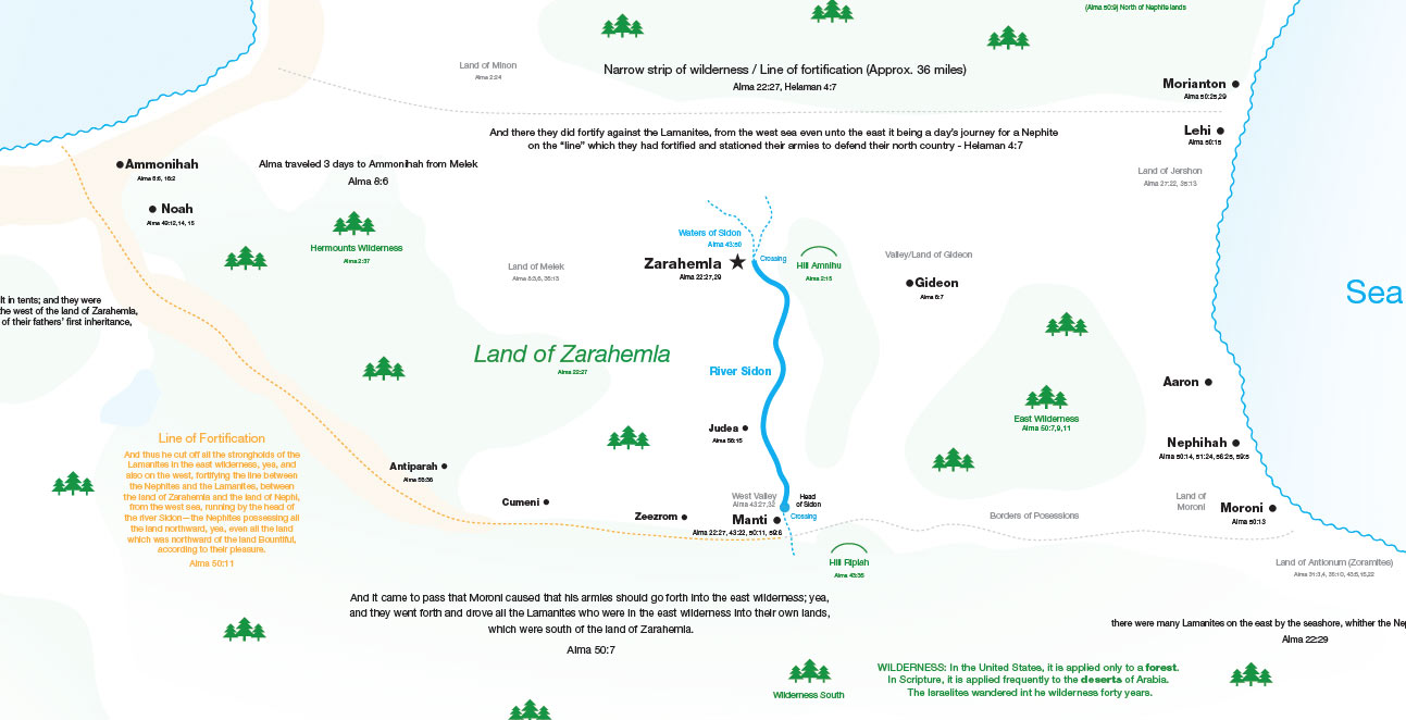
I wanted to produce a map that was as true as possible to the text. Using the text alone, I have attempted to build the Land of Zarahemla with its cities and the surrounding territories on textural clues and a few daring assumptions that challenge other models out there. I’m not an expert at this but as I’ve read and re-read the Book of Mormon and am continually fine-tuning my map, this is where I’m at thus far.
Note that I am not suggesting that this model is perfect by any stretch, it is a work in progress. Almost every location is referenced by scripture in the map itself so you’ll have to zoom in a little, I tried to make the map as close to proper scale as possible.
A few observations:
- My map estimates the Land of Zarahemla to have been approximately 36 miles wide and surrounded not only by various water features but forests and possibly very rough or even impassible terrain in the west around to the southwest.
- I think Zarahemla and Manti were key crossing points on the Sidon river at the northern and southern regions of Zarahemla and that they used the impassable middle portion to their strategic advantage.
- I think the narrow neck of land was actually a pass that was a convenient way into the land northward on the coast of the west sea and that there was perhaps an inland lake or “sea” or impassible rocky terrain that made the “narrow neck” a much easier route. I believe it was small enough to be guarded by an army, but that the distance between the sea east and the sea west at this point was around 54 miles wide, wider than the land of Zarahemla.
Using this model has helped me discover a lot of things that were not apparent in the text. I’ve gained some insight on the age of Alma the Younger at the time of his conversion (article pending) and why certain military strategies were employed and the strategic positioning of Ammon’s converts in Jershon.
While my map is probably far from perfect and it can be a little difficult to gauge many of the distances, especially the North/South distances, this map is a rough estimate of the general layout. I have not yet gone into the Lamanite lands or the land of first inheritance as of yet.
The map is open source and free to the public and can be edited easily in Adobe Illustrator. If you find any errors or any possible additions to the map, please let me know in the comments and I’ll take your suggestions into consideration.
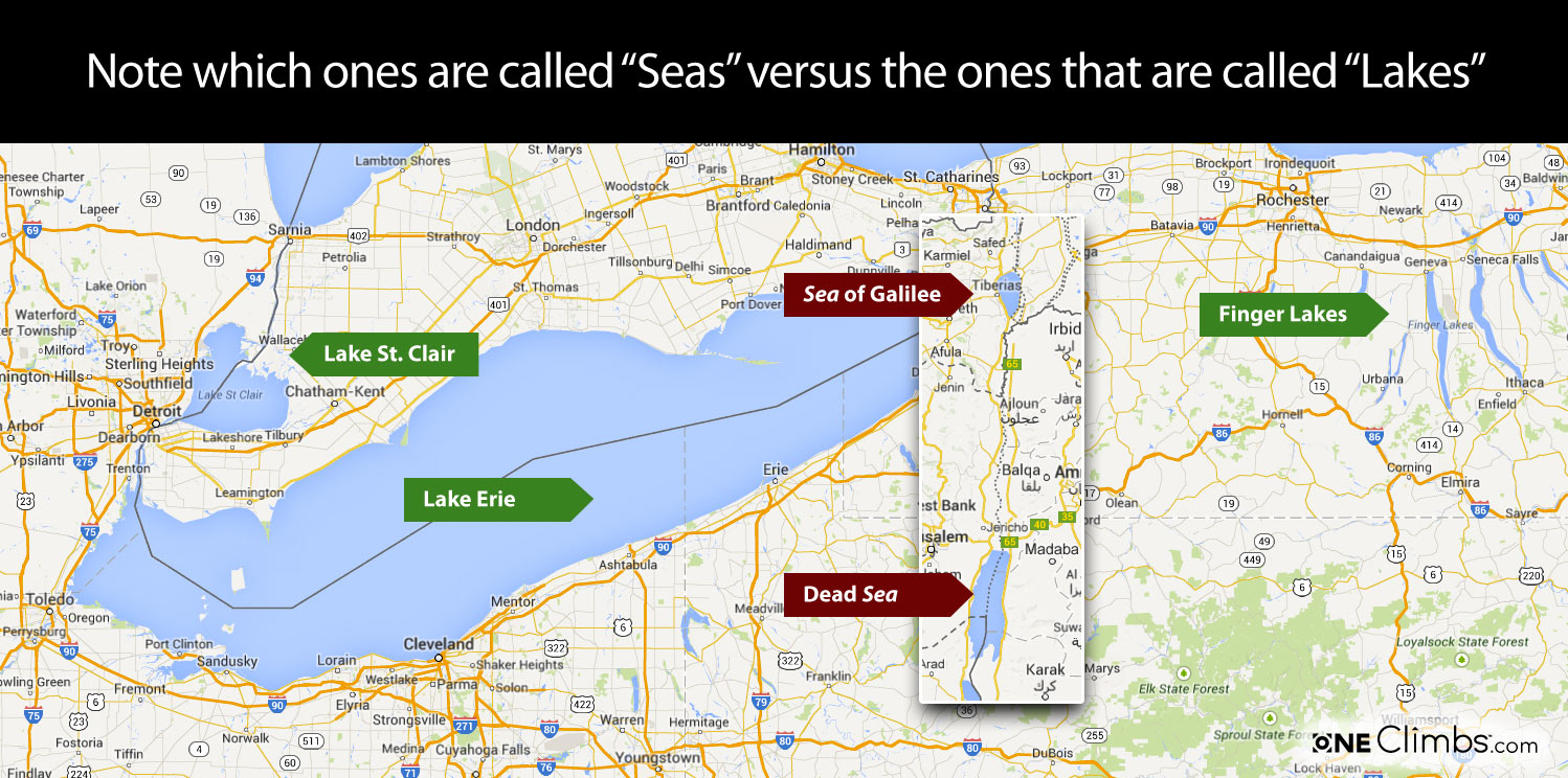
Seas vs. Lakes
The image below is only for size comparison, I’m not making any claims. We just don’t really know how large or small the east and west “seas” were in the Book of Mormon. I think sometimes we envision them as oceans and look for something more like the Pacific and Atlantic oceans flanking Central America.
As I read the text, I believe that there is probably evidence that one could travel further west than the shore of the west sea and further east than the shore of the east sea. One way this would be possible is if Zarahemla was positioned roughly between the south shores of two seas. I think the south shore of the west sea was potentially a little further north than the south shore of the east sea.
Illinois Map
In Doctrine and Covenants section 125:3 we read the following which is a revelation to Joseph Smith:
Let them build up a city unto my name upon the land opposite the city of Nauvoo, and let the name of Zarahemla be named upon it.
There’s no verse that explicitly says “Zarahemla was on the west side” of the Sidon river — it’s inferred from battle movements, travel routes, and directional language. It also appears that the Sidon river was passable on foot at least near Zarahemla.
This would make the city of Zarahemla an extremely strategic location to allow or refuse passage into the land of Zarehemla, Bountiful, and the land Northward.
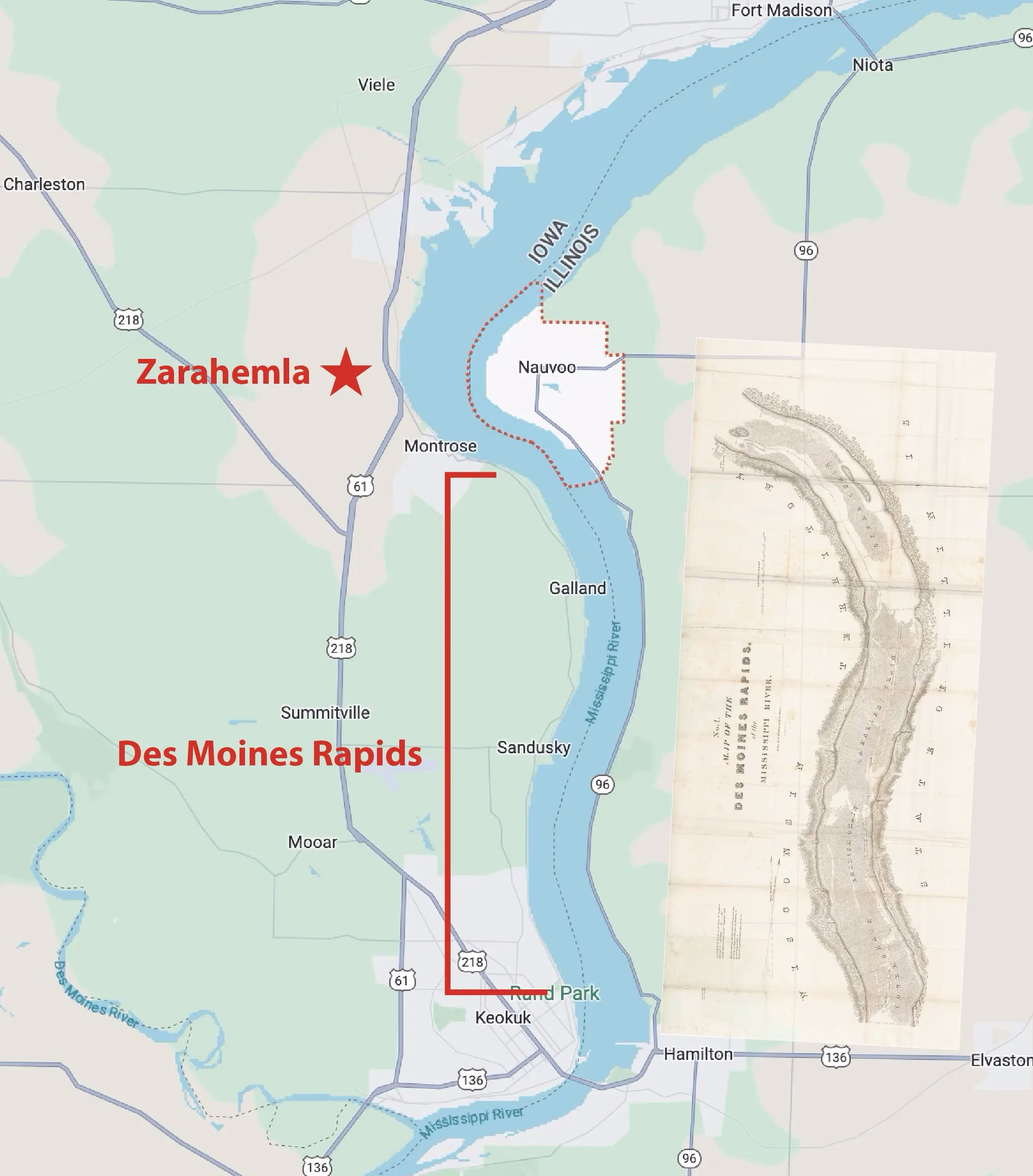
In the early 1800s, the Mississippi River near this Zarahemla site and Nauvoo, Illinois, was only partially navigable due to the nearby Des Moines Rapids, located just downstream near Keokuk, Iowa. These rapids stretched about 11 miles and were shallow, rocky, and hazardous, making them a major obstacle for steamboats and cargo vessels—especially during low water seasons.
As a result, boats often had to offload cargo and portage around the rapids. Efforts to improve navigation began in 1837, with blasting and canal construction, and by 1877 the Des Moines Rapids Canal opened. Eventually, the installation of Lock and Dam No. 19 submerged the rapids completely, allowing full river navigation through the area.
I think it’s interesting that this Zarahemla site mentioned in the Doctrine and Covenants corresponds with the historical Zarahemla which was also on the west of a major river that had a place you could pass nearby.
So I think it is worthwhile considering if there is a possibility of this being the actual historical location for the ancient city of Zarahemla. I’m not the first to suggest this, there are other maps out there.
But I decided to overlay my abstract map onto this location and see what I could find.
It would take quite a bit of explanation to justify the placement of each city and feature of the map. I don’t know when I can get around to it but one thing you’ll notice is that there are some inland seas on my map that don’t exist in the present.
I think it is possible that these seas existed in ancient times due to examining topographical maps to see where you could see where the rivers would or could have been wider due to flooding or perhaps formed into larger bodies of water from the destructions after Christ’s death and possibly from periodic changes of the land due to the New Madrid earthquakes which could have drained these inland seas.
“And the city of Moroni did sink into the depths of the sea, and the inhabitants thereof were drowned. And the earth was carried up upon the city of Moronihah, that in the place of the city there became a great mountain. And there was a great and terrible destruction in the land southward. But behold, there was a more great and terrible destruction in the land northward; for behold, the whole face of the land was changed, because of the tempest and the whirlwinds, and the thunderings and the lightnings, and the exceedingly great quaking of the whole earth; And the highways were broken up, and the level roads were spoiled, and many smooth places became rough. And many great and notable cities were sunk, and many were burned, and many were shaken till the buildings thereof had fallen to the earth, and the inhabitants thereof were slain, and the places were left desolate. […] And thus the face of the whole earth became deformed, because of the tempests, and the thunderings, and the lightnings, and the quaking of the earth. And behold, the rocks were rent in twain; they were broken up upon the face of the whole earth, insomuch that they were found in broken fragments, and in seams and in cracks, upon all the face of the land.”
3 Nephi 8:9-14, 17-18
Earth was carried up, mountains appeared, cities were sunk, the only way for that to occur is if there were massive changes to the elevation of the land in the area.
What if after the death of Christ and the mass destructions in the area that these inland seas were drained to open up the land more which would have left the land of Zarahemla more exposed to the Lamanites.
But after Christ’s death there were no more -ites, at least for several generations so a fortified land wouldn’t have been as necessary.
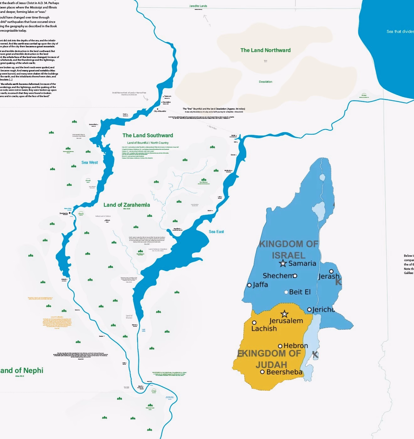
I think it’s very possible that the land of Zarahemla was small, about the size of the ancient lands of Israel and Judah. When you compare my proposed map to these lands in the Middle East, note the sizes of the SEA of Galilee and the Dead SEA.
What were considered “seas” anciently, at least to Biblical people would probably be synonymous to what we call “lakes” today. In fact, the word lake is only mentioned 5 times in the Bible and all in the New Testament. Four references refer to a “lake of fire” and one mentions the “lake of Gennesaret” (Luke 5:1) which is actually a reference to the Sea of Galilee.
So there are a lot of semantics at play here. Seems that in the Bible a “sea” was simply a large body of water. The Bible never seems to explicitly mentions oceans though, perhaps because their world was pretty small.
“Lake” was an understood term in Joseph Smith’s time but there’s no mention of the word “lake” or even “ocean” in the Book of Mormon to describe a body or water. We see the word lake as well but, like the New Testament, it is only in relation to the “lake of fire.”
The only descriptors for water that we find are words like:
- Seas
- Waters
- Fountains
- Rivers
- Large bodies of water
Not very helpful language but I think it’s important to understand that a “sea” could look something more like a “lake” and be rather small. North American rivers can flood easily and I think it’s possible that major quakes could alter the topographic to create or drain inland “seas.”
There are many other things I could say about these maps and how I reasoned upon many things depending on military campaigns, movements of people, or other factors in the text. I included many references so you can look up things for yourself.
This is a work in progress and some things are more speculative than others so take that into consideration. I think there are many other potential possibilities out there but this is just my take thus far.
4 Comments
Nice map, but you should check out the book The Lost City of Zarahemla to see how the North American model fits–and why the Mesoamerican theory got started in the first place.
Looks like an interesting book, I haven’t heard of it before. I tend to be of the opinion that the events in the Book of Mormon occurred mostly in the Eastern United States and possibly Canada (Jaredites) but I’m no “expert.”
Beautiful map, but you should put pictures of “wild and ravenous beasts” in the Hermounts wilderness. And maybe a couple vultures feeding on human prey……just an idea of course : )
Thanks, Richard, I knew it was missing something ;)